Travel map: Difference between revisions
Jump to navigation
Jump to search
mNo edit summary |
No edit summary |
||
| Line 6: | Line 6: | ||
*Yellow - Travelling vessel required, usually in the form of paid transportation. |
*Yellow - Travelling vessel required, usually in the form of paid transportation. |
||
*Grey - Time-based choke point. E.g. an icy road that you must slowly travel through. |
*Grey - Time-based choke point. E.g. an icy road that you must slowly travel through. |
||
<imagemap> |
|||
Image:TravelMap.png|frameless|upright=5 |
|||
rect 14 13 101 38 [[RanikMap47|City of Muspar'i]] |
|||
rect 122 14 214 41 [[RanikMap48|Velaka Desert Trail and Sand Barges]] |
|||
rect 11 103 101 133 [[RanikMap48|Velaka Desert Trail and Sand Barges]] |
|||
rect 118 52 176 95 [[RanikMap48|Velaka Desert Trail and Sand Barges]] |
|||
rect 208 62 279 90 [[RanikMap45|Town of Hvaral and the Road to Fornsted]] |
|||
rect 296 61 378 88 [[RanikMap44|Fornsted Village]] |
|||
rect 290 103 386 130 [[RanikMap43|One travel that takes a substantial amount of time, not RT, but not capable of doing much else]] |
|||
rect 411 101 558 129 [[RanikMap42|The City of Therenborough]] |
|||
rect 320 169 411 197 [[RanikMap149|Siksraja Village]] |
|||
rect 433 170 538 198 [[RanikMap40|City of Langenfirth]] |
|||
rect 567 145 645 172 [[RanikMap34c|Rope Between Rossman's Landing and Therenborough. Large RT getting off rope. (~ 150 Athleticism)(~240 Combats for Bandits on south side) ]] |
|||
rect 681 153 839 182 [[RanikMap34|Mistwood Forest to Rossman's Landing]] |
|||
rect 26 67 86 92 [[RanikMap48|Velaka Desert Trail and Sand Barges]] |
|||
rect 119 101 178 132 [[RanikMap48|Velaka Desert Trail and Sand Barges]] |
|||
rect 411 216 509 258 [[RanikMap40|Balloon to M'riss in Langenfirth]] |
|||
rect 566 194 648 240 [[Lake Gwenalion|Boat rental service that can travel to Langenfirth, Riverhave, and Rossman's Landing]] |
|||
rect 710 202 809 244 [[RanikMap34|Jantspyre River (~150 Athleticism)]] |
|||
rect 567 256 644 283 [[RanikMap30|Ferry between Riverhaven and Langenfirth]] |
|||
rect 682 263 839 291 [[RanikMap30| The City of Riverhaven]] |
|||
rect 864 260 964 295 [[RanikMap31|Zaulfang swamps and path to Maelshyve's Fortress]] |
|||
rect 566 294 676 337 [[RanikMap30|Boats to Ratha and Aesry from Riverhaven]] |
|||
rect 700 321 758 344 [[RanikMap30|Ferry from Riverhaven across the Faldesu to Greater Fist]] |
|||
rect 769 313 833 356 [[RanikMap14c|Faldesu River (~120 Athleticism)]] |
|||
rect 842 314 924 347 [[RanikMap30|Ferry from Riverhaven down the Faldesu to Throne City]] |
|||
rect 950 326 1067 360 [[RanikMap35a|Throne City]] |
|||
rect 1356 316 1420 349 [[RanikMap98|Aesry Surlaenis'a has a lot of climbing as soon as you get off the dock, and regular movement around the island is very fatiguing.]] |
|||
rect 678 372 812 405 [[RanikMap14|Greater Fist]] |
|||
rect 1191 358 1255 390 [[RanikMap90|Island of Ratha]] |
|||
rect 1280 354 1340 384 [[RanikMap90|Boat between Ratha and Aesry]] |
|||
rect 756 428 867 460 [[RanikMap13|NTR near Caravansary and Dirge]] |
|||
rect 970 426 896 464 [[RanikMap13|Dirge]] |
|||
rect 1192 423 1289 479 [[RanikMap90|Boat and Moongate bewtween Ratha and Taisgath, the Moongate requires at least one mooon be up.]] |
|||
rect 1297 436 1359 465 [[RanikMap90|Boat between Ratha and Hara'jaal]] |
|||
rect 824 471 943 504 [[Sunfall Hub|Village of Sunfall Hub]] |
|||
rect 1190 495 1280 529 [[RanikMap90d|Taisgath Island]] |
|||
rect 1376 471 1462 505 [[RanikMap106|Hara'jaal Island]] |
|||
rect 710 515 787 563 [[RanikMap9|Kaerna Village]] |
|||
rect 827 513 935 553 [[RanikMap10|Stone Clan]] |
|||
rect 1307 534 1366 564 [[RanikMap107|Boat between Mer'kresh and Hara'jaal]] |
|||
rect 311 547 417 583 [[RanikMap5a|Knife Clan]] |
|||
rect 1188 571 1297 621 [[RanikMap107|Mer'kresh City and M'riss Island]] |
|||
rect 314 624 421 661 [[RanikMap5|Wolf Clan]] |
|||
rect 442 593 527 626 [[RanikMap4|Brook to Knife Clan and Wold Clan]] |
|||
rect 610 589 740 651 [[RanikMap1|The Crossing]] |
|||
rect 765 583 875 620 [[RanikMap7b|Arthe Dale]] |
|||
rect 500 647 607 683 [[RanikMap4a|Tiger Clan]] |
|||
rect 617 666 701 715 [[RanikMap60b|Swimming the Selgotha River between Crossing/Tiger Clan and Leth Deriel(~350 Athleticism)]] |
|||
rect 708 675 770 705 [[RanikMap1|Ferry across Selgotha River between Crossing and Leth Deriel]] |
|||
rect 782 644 859 692 [[RanikMap1|Boat between crossing and Ratha]] |
|||
</imagemap> |
|||
Revision as of 14:31, 12 April 2015
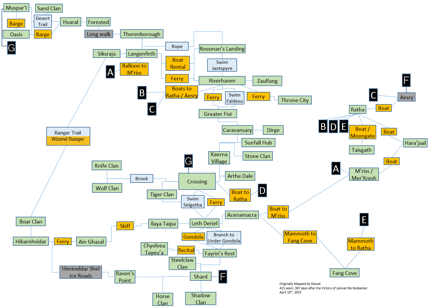
This is an overview of the major travel routes throughout Elanthia. It is not to scale. See the Zone map for a map which shows the actual direction and distance between locations.
Map
- Line - You can walk around fairly normally, although there may be some very minor athleticism checks that even novice travellers should be able to succeed at.
- Blue - Requires some considerable amount of athleticism to bypass.
- Yellow - Travelling vessel required, usually in the form of paid transportation.
- Grey - Time-based choke point. E.g. an icy road that you must slowly travel through.

