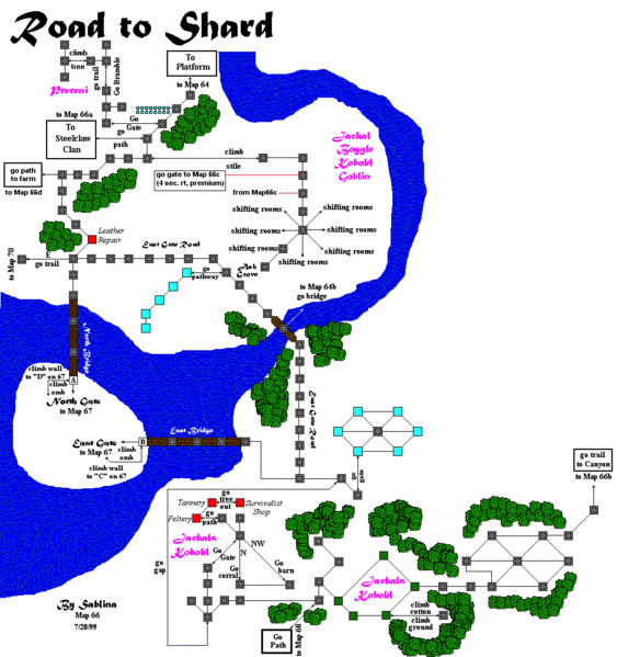
File:Map66.gif
Jump to navigation
Jump to search

Size of this preview: 563 × 599 pixels. Other resolution: 992 × 1,056 pixels.
Original file (992 × 1,056 pixels, file size: 65 KB, MIME type: image/gif)
Bottom of the STR and Road to Shard
Ranik Map
File history
Click on a date/time to view the file as it appeared at that time.
| Date/Time | Thumbnail | Dimensions | User | Comment | |
|---|---|---|---|---|---|
| current | 01:48, 5 October 2022 |  | 992 × 1,056 (65 KB) | KNGDABOMB (talk | contribs) | Added Prereni hunting area and housing area |
| 23:39, 13 June 2017 |  | 992 × 1,056 (67 KB) | GNIKOLEYCHUK (talk | contribs) | ||
| 18:16, 13 June 2017 |  | 992 × 1,056 (61 KB) | GNIKOLEYCHUK (talk | contribs) | Corrected the position of the entrance to sunbeam circle | |
| 20:32, 23 June 2015 |  | 992 × 1,056 (62 KB) | LOREALI6 (talk | contribs) | {{Ranik Map}} | |
| 03:29, 21 June 2015 |  | 992 × 1,056 (62 KB) | LOREALI6 (talk | contribs) | {{Ranik Map}} | |
| 01:38, 14 June 2015 |  | 992 × 1,056 (62 KB) | LOREALI6 (talk | contribs) | {{Ranik Map}} | |
| 01:38, 14 June 2015 | No thumbnail | 992 × 1,056 (62 KB) | LOREALI6 (talk | contribs) | {{Ranik Map}} | |
| 15:06, 7 February 2014 |  | 992 × 1,056 (57 KB) | Maintenance script (talk | contribs) | Importing image file |
You cannot overwrite this file.
File usage
The following page uses this file: